
GHOSTS OF SASKATCHEWAN

The Second World War was a time of powerful stresses on nations, on ethnicities, on families, and on economies around the globe. Hundreds of thousands of families, in every corner of the world, would offer up, with grim reluctance, their sons and even daughters and lay them down on the altar of liberty. The best of this young generation were to be given the task and the training to push back a darkness which was devouring freedom, territory and lives. They were about to save the world.
From 1939 to 1944, as part of this global sacrifice, there was a great gathering that brought together young men from around the world. It was a coming together of avenging angels – men who would take the fight against this darkness to the air in proportions not even dreamed of just a few years before, in machines of great power and lethality. Though the souls for the task at hand were drawn from disparate places like New Zealand, Jamaica, Scotland, Norway, and Australia, the trysting place would be the small towns and rural hamlets of Canada as well as larger urban centres such as Moncton, Toronto, Fort William, Winnipeg, Calgary and Vancouver, to name just a few..
Men boarded great grey ships at Sydney's Circular Quay or perhaps the docks of Great Britain, rode trains from Toronto's Union Station, or walked across the border from the United States and resolutely made their way through initial training schools to the vast, sky-dominated and peaceful prairie landscape. As part of the British Commonwealth Air Training Plan (BCATP), Canada would put into motion a logistical and engineering project of such monumental proportions for the country of only eleven million citizens, that it dwarfed the building of the Canadian Pacific Railway, the ribbon of steel that united our country before confederation – something Canadians consider the gold standard in federal infrastructure projects. Inside of two years, Canadians scouted, surveyed, and built more than 150 airfields, established almost 100 training schools for pilots and aircrew, built the syllabi and training equipment and the thousands of aircraft needed. The cost exceeded 2.25 billion in 1939 dollars (approximately 36 Billion dollars today), and Canada paid for 75% of it.
During this build-up time, recruitment began in earnest and in all corners of the country and the Commonwealth – a cattle farmer's son from Victoria, Australia, a bookkeeper from Oshawa, Ontario, a missionary's son from Philadelphia, a gas jockey from Sherbrooke, Québec, an apprentice butcher from Aberdeen, Scotland, a law student from Montréal, Québec. The system sorted them out by skills or needs, assigned them to schools across the country, and fed them into the maw of the BCATP.
Canadian BCATP bases were spread from coast to coast, but primarily they took place in the Canadian provinces of Alberta, Saskatchewan, Manitoba, and Ontario. To make room for flying operations, and to keep the skies relatively uncrowded, these airfields and schools were dispersed far and wide, with most of them located within 5 to 20 kilometers from a small rural town. This was done to maintain proximity to a source of support workers, materiel and food as well as give marooned students some sort of night life. For many of these bases, one, two, or even three relief landing fields were created to relieve congestion at the main field as scores of aircraft shot touch-and-goes and did circuits. In themselves, these were often complete airports with buildings and paved runways and staff.
If you grew up in a small village like Dafoe, Saskatchewan in the 1930s, life was nothing short of predictable. Work was never ending, winters were hard, oh so hard, church was obligatory, marital prospects were limited, and one's view of the world at large was what you could glean from newspapers. The great tectonic shifts in world politics, militarism and technology were things that happened over the horizon – far, far over the horizon. But in 1940, the world at large, with its fears, stresses, strange accents and brave young men came marching over that horizon and encamped just outside of the town limits of many a small town in Canada.

The men who would populate the schools across the country were brought there by the trains of theCNR and CPR. Overnight, the great railway system of Canada was primarily in the employ of the war effort. Here, a recently graduated class of observers/navigators from No. 31 Air Navigation School pose with the train that will take them from the small town of Goderich, Ontario to their uncertain futures at the war front. Photo via Phil Wilson
Suddenly there were year-round jobs for men and women. There was local business growth where there had been nothing for decades, save a shrinking economy shattered by the Great Depression. Everyone was benefiting from these new aviation schools – from bakers and builders to teamsters and casket makers. Every room in town that could be rented was filled with military and civilian instructors. Overnight, there were hundreds of virile, exuberant, polite, and lonely young men walking around town. Local society was transformed in a Prairie heartbeat. There were dances, socials, fundraisers, love affairs and barroom fights. The impacts on these small towns were huge and, for some like Moose Jaw, Saskatchewan, they would be permanent. In some towns, the BCATP blew through town like a summer prairie storm, straining the fabric of the community for just a couple of years and then it was gone, or at least the flow of young men who brought it to life had dried up overnight and the bases were closed. Some large bases, populated by more than a thousand students and staff, were opened and shut down in just two years. The local economy went from zero to a hundred miles an hour and back down to zero just as quickly.
The network of BCATP schools was established in breathtaking speed. Some airfields were operational within a year. The last came online in 1942. Despite the stupendous cost and effort to create these schools and despite the success of the project and massive output of qualified and motivated young aviators, war planners could read the writing on the wall. The darkness was receding, the fascists were weakening and reeling backwards. Soon, the bloodletting would stop. It was time to cut the flow of blood off at the source – the British Commonwealth Air Training Plan. By late 1944 and early 1945, a few of these brand new schools were shut down and the bases closed.
Some, like Moose Jaw, Portage La Prairie and Bagotville, remain as RCAF bases to this day. Others, like Claresholm and Penhold, would be reactivated for military training service after a short closure and then fade away. Some saw a short-term second life as storage, maintenance and disposal facilities for the thousands of training and combat aircraft that had been needed for the war effort, but were now surplus to requirements. The lucky ones, located near larger communities such as Prince Albert or Arnprior were, in time, handed over to the communities that birthed them, to become the local airport and the seed for industrial development. Many still function today.
Almost all the relief landing fields and many of the more remote bases have declined, deteriorated, or simply vanished, consumed by the landscape that once fostered them. All that remains of many are crumbled runways, hangar floor slabs, abandoned gunnery backstops (gun butts) and, in some cases, just a faint wisp of memory, a discolouration upon the land. Only one base, No. 31 Bombing and Gunnery School (B&GS), at Picton, Ontario, exists intact to this day – a time capsule from a period most Canadians have forgotten.
Recently, while flying across the Prairies with Bruce Evans in his T-28 Trojan, we spotted one single BCATP base off to the south of our track, its broken runways catching the light enough to distinguish it from the surrounding farmland. There was but one structure where once there had been a small town. It was a ghost, caught in the open sunlight, a single footprint from a massive military beast, left upon the prairie. It got me to thinking: “What is still visible of this enterprise today?
Using Google Maps-Satellite as a camera, I searched the Prairies for the remains of the greatest engineering accomplishment in Canadian history. Scrolling across the countryside in “my satellite”, many of the familiar triangular airfields, invisible from a passing car, were clearly visible. Others had left only the faintest of spoor, while others had vanished into the prairie grass. Using the Canadian province of Saskatchewan as my boundary, I tracked down, via satellite, all that is still visible from above today. Seventy years from now, much of what you will see in the following images will cease to exist. Here now, compiled for your edification, are all the bases of the BCATP that were located in Saskatchewan – what they look like today, a few thoughts about their past, a few images from the war or their later life, a wave goodbye.
In the months ahead, we hope to bring your similar stories on Alberta, Manitoba, Ontario and the rest of Canada. I was aided in my search by a fantastic website written and compiled by Bruce Forsyth called MilitaryBruce.com. Bruce, a former naval reservist, has listed and written about every abandoned military facility in Canada. Using some his notes and writings, as well as many other sources, I was able to compile a very brief history of these once great air force facilities. In addition, friends on Flickr gave me permission to use their posted images, and town websites were used for additional colour. I also thank the incredible minds that gave us Google Maps/Google Earth. It's a great way to travel back in time.
The BCATP in Saskatchewan
No. 34 Elementary Flying Training School (EFTS), Assiniboia
and No.25 Elementary Flying Training School
Originally opened by the Royal Air Force on 11 February 1942, No. 34 EFTS was located near the small South Saskatchewan town of Assiniboia. In addition, a relief landing field was constructed near Assiniboia at a place called Lethburn (where there stood a school, named after the two ends of the Canadian Pacific Line that ran through Assiniboia: Lethbridge, Alberta and Weyburn, Saskatchewan). No. 34 EFTS trained RAF pilots on the Fairchild Cornell and was managed by the civilian Winnipeg Flying Club. One of the longest serving instructors there was Flight Lieutenant Archie Pennie, to whom our Fairchild Cornell is dedicated. Archie accumulated nearly 700 hours on the Cornell while instructing pilot trainees at the facility.
Living near the end of one of the three Assiniboia runways was a young boy by the name of Harry Whereatt. Harry, inspired by the pilots and instructors who flew overhead, would become a pilot and Aircraft Maintenance Engineer (AME). More than that, Whereatt would collect surplus aircraft after the war and would spend a lifetime restoring them to flying condition. The Vintage Wings of Canada Lysander and Canadian Car and Foundry-built Hurricane XII were two of Harry's most successful restoration projects. Sadly, Harry died this year
No. 34 EFTS closed on January 30th, 1944. The aerodrome was taken over by the RCAF and No. 25 EFTS stood up in its place. No. 25 EFTS had a brief existence though, and by the time it closed on July 28th, 1944, 2,560 student pilots had graduated from Assiniboia under both schools
In August 1944, two new units stood up at the aerodrome: No. 41 Pre-Aircrew Training School (PATS), with a mandate to provide academic training, and No. 403 Aircraft Holding Unit (AHU), – a storage operation for Second World War surplus aircraft. Both units closed in 1945.
Very little remains of the old school today, with only the airfield and the gun butts remaining. All the buildings were either torn down or moved off-site. Two hangars were moved to Regina and the drill hall to Moose Jaw. The hospital, recreation hall, workshop, officers' barracks and the dental building were moved to Assiniboia itself
The airfield is now the Assiniboia Airport. A cairn was constructed on the property to pay tribute to the personnel who served at both No. 34 & No. 25 EFTS.
Related Stories
Click on image


After completion, a photograph was taken of each of the BCATP airfields. This one, shot from due west, was probably taken in the summer of 1942. Located 13 kilometers to the northeast of Assiniboia, Saskatchewan, No. 34 EFTS was, for Commonwealth pilot trainees at least, quite decidedly in the middle of nowhere, on the broad Canadian Prairie. When it opened, the school utilized the de Havilland Tiger Moth, but later, in Archie Pennie's instructing days, the school operated the Cornell. Image via Flight Ontario

Overhead Assiniboia today, we see that only the east-west runway (08-26, bottom of triangular setup) is still functioning as the main airport active runway. The Assiniboia town website speaks only of this runway as being active, but Wikipedia states that runway 13-31 (east side) is still available. Image via Google Maps

One of Vintage Wings of Canada's vintage aircraft, the Fairchild Cornell, is dedicated to one of Assiniboia's great flying instructors of the Second World War – Flight Lieutenant Archie Pennie. Photo: Peter Handley

Today, the Assiniboia hangars have been demolished, but their concrete slab floors are still in evidence beneath newer and smaller structures. We can understand the size of the original hangars by comparing the size of the Cessna on the ramp with their footprints. Photo by Kdmit on Panoramio

Down at ground level, at the threshold of runway 26, we see what those RAF pilot trainees saw 70 years ago... nothing but prairie. The trees and buildings at the right in this shot are actually legendary aircraft restorer Harry Whereatt's family farm yard. Thinking of his friendship with Harry, Vintage News subscriber Randy England says: “ I last talked to him a couple of summers ago. The Assiniboia Air Cadets do a fly in lunch and they always had a tour of Harry's place. Knowing him slightly, I stayed behind the rest of the tour and helped him close up his hangars. We had a really nice chat. We talked about his planes and his Tiger Moth in particular. He told me how he'd never sell it because it was the first plane he ever owned. He was a true gentleman. Ha, I remember him telling me another time about his Hurricane. (sorry the memories are starting to flow a bit). It took him the better part of 30 years to finish it. "That's because I did it 3 damn times" he said. "I'd get it put together then realize I did something wrong inside and have to take the whole damn thing apart again! And I did that 3 times." He forgot to tell me that he also restored the Lizzie at the same time!!. I asked if he was going to fly the Hurri. "Yup. With all that work I want to have a ride in it." ” Sadly, Harry, who was the original restorer of the Vintage Wings of Canada Lysander and Hurricane XII, passed away this year. Photo by Kdmit on Panoramio
No. 33 Elementary Flying Training School, Caron
No. 33 EFTS was opened by the Royal Air Force on January 5th, 1942, near the small prairie town of Caron, Saskatchewan. The facility was managed by civilians from the Aero Club of British Columbia and performed elementary flying training on the Fairchild Cornell. A relief landing field was constructed near the hamlet of Boharm. As the British Commonwealth Air Training Plan wound down at the end of the war, the flying school closed on January 14th of 1944. During its operational life, Caron graduated 1,837 airmen who went on to service flying training. Sadly, like many operational flying schools of the BCATP, ten airmen lost their lives in flying accidents while stationed at the airbase.
33 EFTS was established and operated by the Royal Air Force at its inception. 18 EFTS Boundary Bay BC was closed because of pressure brought on by the training of aircrew in B-24s and other large operational aircraft on the coast. 18 EFTS was ordered to take over the Caron school on April 30, 1942. In fact, 18 EFTS was permanently closed on May 20, 1942. The Boundary Bay Flying Training Company did, however, take over the training operations of what remained as 33 EFTS, under the direction of RAF (and later RCAF) supervisory personnel.
The Caron aerodrome continued in the employ of the BCATP after the closing of No. 33 EFTS as a relief landing field for No. 32 Service Flying Training School (SFTS) Moose Jaw, then abandoned. In a swords-to-ploughshares switch, the site was taken over by the Briercrest Bible Institute and renamed Caronport in 1946.
Today, the Briercrest Family of Schools, consisting of Briercrest College and Seminary and Caronport High School, carry on the tradition of providing education at Caronport. The 160 acre campus is home to 1,200 permanent residents and approximately 1,000 students. The village of Caronport is now much larger than the old town of Caron.
A significant portion of the former station remains. One hangar, the Mess Hall, PMQs, the Recreation Centre (although extensively refurbished), one H-hut (originally a classroom, but now used as a dormitory) and various smaller buildings remain. The main airfield no longer remains, but the taxiways now serve as streets for trailer homes. One of the hangars has been converted to a Sports Arena. The site originally featured thirty buildings and a large, paved runway system. Caronport's Larch Street was once a taxiway along the main runway which ran just north-east of Spruce Street.

An aerial portrait of Caron from the BCATP days taken from due south. H-hut barracks and hangars have been newly completed and the runways are freshly paved if not yet marked. Photo via Flight Ontario

Today, No. 33 EFTS Caron is known as the community of Caronport – a college town for bible studies. When I was young, I dated a girl who left Ottawa to attend this very school. From this satellite image we can just make out the ghostly lines of the old triangular runway system. To the west runs the Trans-Canada Highway. Image via Google Maps

Until recently, when a new arena was built, one of the No. 33 EFTS hangars served the purpose for many decades. Photo: Daryl Sawatsky

One of the original H-hut structures from the old base still serves as a dormitory in modern Caronport, though whitewashed now. Photo: Ben Berg, benlarhome on Flickr

The original town of Caron lies about 3 kilometers to the west of Caronport. While Caronport is the largest registered village in Saskatchewan (larger than many towns), Caron now has only a population of 120. Caron was originally a CPR siding when it was founded in 1882 and was named after Sir Adolphe Caron, then Canadian Minister for Militia and Defense. Image: Google Maps
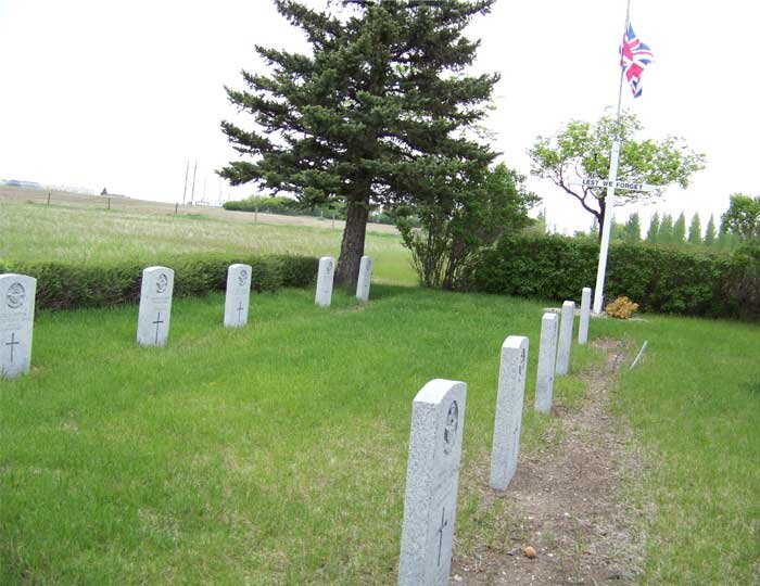
There can be no more powerful statement to the history of Caron's BCATP contribution, than the graves of the ten RAF pilot trainees and instructors at Caronport's graveyard who paid the ultimate price for their willingness to help. Photo: Gregory Melle
No. 5 Bombing and Gunnery School, Dafoe
The community of Dafoe, Saskatchewan, is located on the south shores of the Quill Lakes region of South Saskatchewan. In 1940, this was a very remote part of populated Canada. Unlike most airfields which are located fairly close to their namesake towns, the Dafoe base was situated more than 20 kilometers from the town itself. Opened on January 7th, 1941, No. 5 B&GS closed on January 11th, 1945. Aircraft used at the base include the Westland Lysander, Bristol Bolingbroke, Avro Anson, and primarily the Fairey Battle.
The former station property is now used for farming. The only building that remains is one of the hangars. The only other remnants are the hangar pads, the gun butt and the crumbling roadways and airfield. The property owner still uses a portion of the old airfield as a private aerodrome.
As recently as this year, however, members of the Commonwealth Air Training Plan Museum's Flying Committee, organized a fly-in to the Dafoe field to rededicate the airfield to No. 5 Bombing and Gunnery School. From Brandon, Manitoba, where they are based, they flew a Harvard, Cornell and Stinson (all in BCATP markings) and held a dedication ceremony on the ramp and in the one remaining hangar. It is great to note that the old field has not been forgotten altogether.

This photo, taken directly above Dafoe during the Second World War, shows us that the base was a large one, as many bombing and gunnery schools were. Visible are six large hangars on the flight line plus large training buildings and many H-hut barracks structures. On the flight line are more than fifty aircraft lined up for the aerial portrait. Image via Flight Ontario

A photo taken on another flight shows a close-up view of the big base and flight line. The hangars are set up perpendicular to the ramp with doors opening, not to the flight line, but to the shared ramps in between hangars. Flowers on the grass spell put No.5 B & G DAFOE, , MAINTENANCE etc. Photo: RCAF
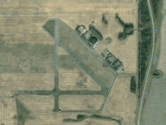
Today, almost none of the original bustling base still exists. Gone are all of the dozens of structures and what was, by Saskatchewan standards, a town site. All that remains is one hangar, used for agricultural equipment storage. Image via Google Maps
Training student gunners and bomb-aimers was not a pleasant task in Saskatchewan during winter. Young pilots, who had joined only months before to fight, were now freezing for hours on end, towing targets and squiring gunners about the Quill Lakes region near Dafoe. Here we see a Dafoe-based Fairey Battle after a winter storm. Starting a Battle frozen solid after the down time was most certainly a painful experience. Photo via CanadianWings.com
Then again, it could also be a very pleasant experience. A pair of Dafoe-based Fairey Battles (including thew same aircraft as in the previous photo) thunder over Saskatchewan farmland near No. 5 Bombing and Gunnery School. Photo via CanadianWings.com
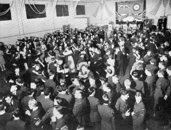
While only memories hang in the air over the old Dafoe base today, once, it was the most exciting place in the Quill Lakes area. Here, young airmen outnumber the local girls at a dance in one of the Dafoe buildings. Photo via rcafdafoeblogspot.ca

Dafoe had its own “Yearbook” publication called Dafoe Doings. One of the pages shows images of all the instructors and the flight line pilots, who called themselves ”The Captains of the Battles” in reference to the Warner Bros. feature film “Captains of the Clouds” released in 1941. Photo via rcafdafoeblogspot.ca

I suppose it is inevitable, but it remains a weight upon our shoulders. The day before we published this story, one of the gunners who graduated from Dafoe's bombing and gunnery school was Medicine Hat, Alberta's Manny Raber passed away after a long battle with Alzheimers. Manny was shot down in his Handley Page Halifax over Belgium and, parachuting to safety, was hidden by the underground. He was eventually captured and spent the remainder of the war as a POW, something that would have been far more dangerous for Manny who was Jewish. Padre David Carter describes Manny as “a wonderful man, friend, mentor and hero”. Tanchumim Raber family

From the highway, only one hangar can be seen today, all that remains of the massive BCATP training airfield.

Nobody does commemoration of the BCATP better than the Commonwealth Air Training Plan Museum (CATPM). Located at the Brandon, Manitoba airport (itself a former BCATP base), the museum is dedicated to commemorating the accomplishments of the BCATP. In July 2012, the CATPM flew three vintage BCATP aircraft (Harvard, Stinson and Cornell) to Wynard, Saskatchewan, a stone's throw from Dafoe. After a Friday nightsleep over in Wynard, the three aircraft then flew to Dafoe and landed there for a rededication ceremony in honour of the rapidly disappearing base. Here, we see the crowd assembled on the old Dafoe ramp for the ceremony. Photo: via the CATPM website
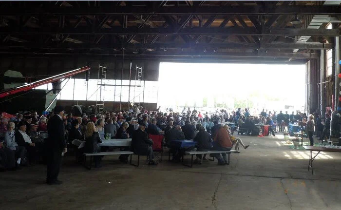
It is clear that the event drew quite a few people from the Quill Lakes region. Here the assembled crowd shares a meal inside the last remaining hangar (No. 5) along with stored farm equipment and some speakers. Vintage Wings of Canada commends and applauds the CATP Museum for their long-term work honouring the BCATP, but in particular, for keeping alive the memory of this important base. Photo: via the CATPM website

One of three former BCATP aircraft types that made the trip from Brandon, the Harvard rolls along the last still-functioning runway at Dafoe. Pilot Harvey McKinnion put on an aerial demonstration for the assembled crowds. Photo via the CATPM website
No. 23 Elementary Flying Training School, Davidson
Davidson is a small town in South Central Saskatchewan, a few kilometers to the east of the northernmost arms of Lake Diefenbaker. It is located 104 kilometers (65 miles) south-east of Saskatoon beside provincial Highway 11, in the rural municipality of Arm River. Sitting almost exactly halfway between Saskatoon and Regina, Davidson's population is a little over 1,000. No. 23 EFTS opened near Davidson on November 9th,1942, under the British Commonwealth Air Training Plan. Of all the EFTS facilities in the BCATP, Davidson was the sole elementary field not under civilian management. It was operated directly by the RCAF. The school relocated to Yorkton in January of 1945. Davidson operated Fairchild Cornell aircraft for elementary training.
From 1957 to 1968, the three 2,500-foot abandoned runways were used as a racetrack for sports car and motorcycle racing. All that remains today of the aerodrome are the abandoned runways and the hangar pads. One of the hangars was moved to the town of Vonda for use as a community ice rink.
It is interesting and possibly a tad disturbing to note that the history section on the Town of Davidson website makes no mention whatsoever of Davidson's important contribution to the war effort with the BCATP.

Davidson was not a large training facility as can be seen in this period photo of the field taken from the north-east. Photo via Flight Ontario

The remains of Davidson as seen on Google Maps look much the same as they do in the previous period photo. Image via Google Maps

As with all BCATP training bases, Davidson was situated close to the town it was named after. Here, we see Highway 11, the Louis Riel Trail, skirting to the north of town. At the time of the BCATP, Highway 11 ran right through town. Image via Google Maps
No. 38 Service Flying Training School, Estevan
No. 38 SFTS, operating the Avro Anson multi-engine trainer, was opened by the RAF on the 1st of April, 1942 near the City of Estevan as part of the British Commonwealth Air Training Plan. Relief landing fields were constructed near the hamlets of Outram and Chandler. The school closed on the 14th of January,1944 after only two years of operation. Given the high cost of such a large training base, shutting it down after less than two years shows that the RCAF was not interested in amortizing its investment over a longer period, but only in the high output of pilots for the war effort.
Plans were made to convert the aerodrome into an RCAF Air Navigation School, but this never came to be. Instead No. 201 Holding Unit was established at the aerodrome, later changed to No. 204 Equipment Holding Unit. No. 204 EHU closed on 30 November 1944.
The final chapter in the military history of the airport came with the founding of No. 4 Surplus Equipment Holding Unit in April 1945, for the purpose of disposing of surplus RCAF war equipment. The unit closed in December 1945 and the aerodrome was turned over to the City of Estevan for use as a municipal airport. The Estevan Flying Club was also formed at the airport at this time.
In 1989, the former No. 38 SFTS aerodrome closed and the property was sold to the Saskatchewan Power Corporation for a coal mine. A new airport was built north of Estevan on what appears to be the site of one of the relief fields. It was located to the south of the town and west of Highway 47. Nothing visible remains of the BCATP aerodrome today.
Of the relief fields, Outram is less than 10 kilometers from Estevan in a direct line. Chandler field is located approximately five miles west of the village of Macoun, on the south side of Township Road 44. The garage and a small building that once housed a generator are still on the property.

No. 38 Service Flying Training School, south of Estevan, Saskatchewan in the 1940s, and only a stone's throw from the border with the United States.

Today, the site of the old No. 38 SFTS has been scoured by coal mining, leaving not a single trace of its former glory and history. Somewhere beneath the scars of this coal mine stands the geographical fix that was Estevan. Image via Google Maps

Though No. 38 SFTS was a huge operation, all traces of its seven huge hangars have vanished as the site's overburden was removed to get at the coal beneath. Here we see the No. 38's flight line and one of the Avro Ansons operated by the facility. Photo via BCMC and Mr. Duane Bill

Avro Ansons on the Estevan flight line during the war years. Photo via BCMC

Not all training at Estevan was successful. There were many mishaps as witnessed by the wreck dump at No. 38 SFTS Estevan. Photo via BCMC

There are three airfields marked on Google Maps as Estevan Airport. This one, called the Estevan Blue Sky Airport far to the north is most likely Shand, one of the three relief fields for the Estevan facility. Image via Google Maps

Outram, Saskatchewan, 25 kilometers west of Estevan, was one of the relief landing fields for No.38 SFTS. Today, nothing remains but the faint vestige of a triangular field. More than most. Image: Google Maps

The relief field at Chandler is located approximately five miles west of the village of Macoun, on the south side of Township Road 44. The garage and a small building that once housed a generator are still on the property The following images are of the remaining structures.


No. 32 Service Flying Training School, Moose Jaw
Moose Jaw, Saskatchewan – there can be no more Canadian sounding town name! For more than 70 years, Moose Jaw has been synonymous with military flying training in Canada. Today's Moose Jaw military base is known as CFB Moose Jaw, home of 15 Wing and 431 Squadron, the Snowbirds Air Demonstration Team. The area surrounding Moose Jaw has a high number of cloudless days, making it a good site for training pilots.
Wikipedia states: “The declaration of World War II saw the Moose Jaw Flying Club initially contracted to provide pilot training for the Royal Canadian Air Force, however this was soon replaced by the far larger British Commonwealth Air Training Plan (BCATP) which saw the Government of Canada acquire the aerodrome and completely reconstruct it into RCAF Station Moose Jaw in 1940 with the new aerodrome opening in 1941.
Initially the Royal Air Force trained exclusively at the base under the RAF's No. 32 Service Flying Training School (SFTS) (ca. 1942) using Harvards, and later, Oxfords. No. 32 SFTS eventually broadened its intake to train 1,200 pilots for the air forces of Canada, the United Kingdom, Norway, New Zealand, Poland, France, Czechoslovakia, Belgium, the United States and the Netherlands.
In 1946 RCAF Station Moose Jaw was decommissioned and the aerodrome was returned to civilian service after the war.
Rising Cold War tensions saw the aerodrome reactivated by the RCAF in 1953 as the site of military pilot training. RCAF Station Moose Jaw undertook additional construction to support its expanded personnel complement. The base was used by the RCAF and its NATO allies for pilot training, using both single-prop World War II-era Harvards and CT-133 Silver Star jet training aircraft. By the mid-1960s these were both replaced by the Canadian built CT-114 Tutor.
In 1968, the RCAF merged with the Canadian Army and the Royal Canadian Navy to form the unified Canadian Forces. The base's name was changed to Canadian Forces Base Moose Jaw, usually shortened to CFB Moose Jaw. From 1968 until the formation of Air Command in 1975, CFB Moose Jaw fell under the direction of Training Command and served to house the Tutor Jet Training Program.
By the early 1990s, CFB Moose Jaw was operated by over 1,300 employees and made a significant economical impact on the region, but pending cutbacks in military spending spread rumours of possible closure of the base. In 1994 Bombardier Inc. put forth a proposal to provide what is now the NATO Flying Training in Canada program. The proposal was accepted and eliminated all worries that the base would be closed. Many of the base's structures were renovated to accommodate new personnel and new training aircraft. Pilots from Denmark, Singapore, Great Britain, Italy, Hungary, Germany, Finland and many other allied nations train at CFB Moose Jaw every year, ensuring the base's future with the Canadian Forces.
During a reorganization at AIRCOM in the late 1990s, CFB Moose Jaw's various AIRCOM units were placed under a new primary lodger unit called "15 Wing"; consequently the base is frequently referred to as 15 Wing Moose Jaw.”

RCAF Station Moose Jaw, Saskatchewan, from the air shortly after its completion on farmland south of the Saskatchewan town that it is named for. This shot, looking west, shows the meandering Moose Jaw River (Originally the Moose Jaw Bone Creek) in the foreground. Photo: RCAF

A perfectly crisp shot of the control tower at Moose Jaw’s 32 SFTS during the period of the British Commonwealth Air Training Plan. Photo via Brent Thistle

An amazing early morning or late afternoon of a Harvard warming up on an empty and frozen ramp in front of the control tower at Moose Jaw. The instructor in the back is just settling in as his student warms the Pratt and Whitney. Photo via Brent Thistle

Staff flying instructors at Moose Jaw in 1940-41. Only the pilot second from the right can be identified. He is Pilot Officer (Later Flight Lieutenant) Ralph Bernard Farmer, RAF Volunteer Reserve who went on to fly Spitfires with 542 Squadron.

In the weak Prairie Spring light, Harvard 2727 runs up (note the chocks), perhaps after being repaired. Harvard 2727 suffered Category C damage on 28 January 1943 while at Moose Jaw. Perhaps this was a post repair test. Photo via Brent Thistle

Three 3-plane “vics” form Moose Jaw form a larger vic over the Prairies with the snaking Moose Jaw river in the background. Photo via Brent Thistle

A great winter aerial of No. 32 SFTS with the city of Moose Jaw visible down the length of 9th Avenue. Photo via Brent Thistle

Sunlight pours into a hangar full of what look like new Harvards. The Harvard at right, RCAF 2637 suffered Category C damage on 9 April 1941 while at No. 32 Service Flying Training School. Perhaps this dates it to on or before that time. Photo via Brent Thistle

Today, the base still thrives, albeit at a much slower pace than in previous decades. In this satellite shot, we can still make out the original triangular runway configuration and the same hangar line, with new modern hangars. On the ramp sit 10 new CT-156 Beechcraft Harvard IIs and five CT-155 Hawks. Image via Google Maps

Pulling back higher, we see the relationship of 15 Wing, Moose Jaw to the city. Today, Moose Jaw is home to 2 CFFTS (Canadian Forces Flying Training School). Image via Google Maps

The primary relief landing field for No. 32 SFTS, Moose Jaw was at Buttress, Saskatchewan (seen here), with nearby Caron being utilized as well. The detachment had 3 asphalt runways 100 feet wide and 2,500 feet long, constructed in the standard triangular pattern. Water reservoirs, a barrack block and a garage were added, but no hangar or control tower or barracks. Airmen travelled the ten kilometers to the site during the day and returned to the main aerodrome at night. RCAF Detachment Buttress was abandoned after WWII. The post-war growth of the RCAF resulted in many Second World War stations being reactivated. RCAF Detachment Buttress reopened in May 1952 once again as the relief landing field for the similarly reopened RCAF Station Moose Jaw. By the late 1960s, with the advent of the Canadair CT-114 Tutor trainer, the Buttress airfield became obsolete and it was once again abandoned, this time for good. All that remains today are the abandoned and crumbling runways. Image via Google Maps

The heydays of Moose Jaw's training operations were in the 1960s to the 1980s, when the base was home to a massive flight line of Canadair CT-114 Tutor training aircraft. The Canadian-designed and -built two-seat jet trainer was the mainstay of the Canadian Air Force as it was known for most of that time. Today, only the Snowbirds and the Aerospace Engineering Test Establishment still operate the type. On the control tower is the emblem of No. 2 Canadian Forces Flying Training School (2CFFTS), The Big Red 2. Photo: A Hunt

Canadair Tutors of The Big Red 2 (No. 2 Canadian Forces Flying Training School) line the ramp during the 1980s. Every pilot in the CAF, whether he or she was going on to fly fighters, transports or helicopters, had to master the Tutor first to get their wings. Photo: A Hunt
No. 2 Bombing and Gunnery School, Mossbank
Opened on the 28th of October, 1940 near Mossbank, Saskatchewan, No. 2 Bombing and Gunnery School was one of the first of the major B&G schools to open. The school closed on the 15th of December 1944, having trained 2,539 bomber-aimers and 3,702 air gunners. The Mossbank Golf Club now occupies much of the property. A rock cairn was constructed at the golf course to pay tribute to the men and women who served at No. 2 B&GS.
The base was as large as a small town and featured five aircraft hangars, barracks and other living quarters for several hundred men and women, a parade square, administrative buildings as well as such amenities as an indoor swimming pool, a tennis court, theatre, an open-air skating rink and two ball diamonds.
Students received classroom instruction at Mossbank as well as extensive in-flight training. Exercises included bomb drops over Old Wives Lake on targets representing German submarines. The students frequently made trips into Mossbank where they frequented “the Hostess Club,” which was set up in the local Masonic Lodge. This proved a popular social spot throughout the war.
All that remains of the old school are the gun butts, the hangar pads and the abandoned and crumbling airfield, which still sees the occasional crop-duster plane. The Canadian Forces Snowbirds, who conduct training over Mossbank, have even been known in the past to use the airfield on occasion.
One of the old aircraft hangars was relocated to Regina and is now known as the Turvey Centre. The building has been extensively renovated and is now used for events such as wedding receptions, hobby shows, swap meets and other activities.

Typical of bombing and gunnery schools, Mossbank was a huge facility during the war with six big hangars on the flight line and a big parade square (at centre of base) for wings parades for bomb-aimers and gunners. RCAF photo via Flight Ontario

Today, only the concrete floor slabs of the hangar line exist of the original site, but the runways are still very evident. The field is closed to all aircraft however. The Mossbank Golf Course occupies the north corner of the field today. Image via Google Maps

A satellite image showing the relation between the old base (lower right) and the town of Mossbank. Image via Google Maps

The massive hangar line at Mossbank under construction in the summer of 1940. While aviation was the future of warfare, much of the facility construction was done with man and horse power. RCAF image via copaonline

One of the graduating classes of air gunners at Mossbank in 1941. Letter “X” on this photo shows airmen who were deceased. It is not known whether these deaths were due to the war or includes post-war natural deaths. Photo via copaonline

The flight line at Mossbank in 1941 showing many Battle aircraft awaiting air gunners for training. BCMC photo from Marty Dewis

135 Squadron Hurricanes gearing up for operations at Mossbank in 1940. Image via Mark Peapell
Not much remains today above the prairie surface except for the concrete gun butts. Photo: Joan Champ

A tragic memorial at Mossbank. As mentioned earlier, the RCAF's Snowbirds demonstration team have used Mossbank as a training area. On the 10th of December, 2004, Captain Miles Selby died in a mid-air collision during training near Mossbank while practicing the co-loop manoeuvre. The other pilot, Captain Chuck Mallett, was thrown from his destroyed aircraft while still strapped into his seat. While tumbling towards the ground, he was able to unstrap, deploy his parachute and land with only minor injuries. Photo: Lori and Toss at Flickr.com
No. 35 Service Flying Training School, North Battleford
The Royal Air Force began flying operations at No. 35 SFTS on the 4th of September, 1941 near North Battleford, Saskatchewan with two relief landing fields constructed near Hamlin and Brada. The school taught multi-engine flying with the Airspeed Oxford. Eventually, as the war wound down, No. 35 SFTS closed on the 25th of February, 1944 at which time the aerodrome was taken over by No. 13 SFTS, originally from St. Hubert, Quebec. No. 13 SFTS lived for no more than a year at North Battleford and was then closed in March of 1945.
From 1962-1963, the abandoned runways were used as a racetrack for sports car and motorcycle racing – one of the most common post war uses of BCATP airfields with asphalt runways. The aerodrome is now known as the Cameron Macintosh Airport. All that remains of the wartime schools are the gun butts and the vehicle maintenance shop. Several of the aerodrome's former buildings were moved to the nearby Sharon Schools.
Two of the original runways remain, one lengthened to 5,000 feet. North Battleford Ultra-lights also uses the airfield for flying training.
The former RCAF Detachment Hamlin is now used as an industrial site. Up to 2007, one of the three runways continued to be maintained for use in agricultural flight training by Battleford's Airspray private airport. The airfield in now closed to all aircraft and none of the RCAF buildings remain.

A great shot, looking southeast, of North Battleford's No. 35 SFTS, located to the southeast of the city. The base consisted of seven major hangars in a semi-circular arrangement. RCAF Photo

A satellite shot showing the Cameron McIntosh Airport, the site of the former North Battleford flyng training school seventy years ago with the BCATP . Image: Google Maps

Zooming into the airport area, we see that the former 35 SFTS's unique three-sided hangar line can be seen clearly, though these are merely hangar floor slabs. As welll we can see the base streets still open and the faint hint of the former triangular taxiway set up inside the three runways. Image: Google Maps

Only the former relief field at Hamlin can still be seen from above, though nothing much exists but the triangular ghost of the old field. Image: Google Maps
No. 6 Elementary Flying Training School
No. 6 Air Observer School, Prince Albert
No. 6 EFTS was constructed in the inside of a broad curve in the Saskatchewan River near Prince Albert and opened on July 22nd, 1940 with relief landing fields located near Hagan and Emma Lake. The facility operated both the Tiger Moth and Fairchild Cornell. The school closed on November 15th, 1944. From the 17th of March, 1941 to November 11th, 1942, the station doubled as No. 6 Air Observer School, bringing Avro Ansons to the flight line.
All that remains of the former No. 6 EFTS are two BCATP-era hangars. A monument was erected to pay tribute to the 17 airmen and one civilian who died in training accidents at the school. The RCAF Detachments at Hagan and Emma Lake no longer exist.

An aerial photograph, looking to the south, of No. 6 Elementary Flying Training School at Prince Albert, Saskatchewan, situated to the north side of the Saskatchewan River.

A post-war air show at the Prince Albert Airport showing derelicts Harvards in the foreground. Photo from the Transwest Air website. Transwest Air is one of the premier operators of helicopters and aircraft in Prince Albert and points north. Image via www.transwestair.com

The modern Prince Albert, Saskatchewan Airport, known toady as Glass Field, sits tucked into a curve of the Saskatchewan River, north east of the city. Prince Albert was the northernmost of all the Saskatchewan BCATP bases and is a stepping off pint today for the north of Saskatchewan. Image: Google Maps

A good view of the Prince Albert airport today, looking east. The main airport structure and former tower can be seen at centre right. Image via www.transwestair.com website

The only remaining heritage building from the days of the BCATP is the central hangar and control tower, not occupied by Transwest Air, a charter company operating charters as well as scheduled service to six Saskatchewan cities from Prince Albert. The company flies a well-maintained fleet of 38 fixed wing aircraft including Saab 340 Turboprops, Beech 1900, King Airs, Twin Otters, Turbo Otters, Beavers etc and six helicopters. Transwest Air is the largest operator at Prince Albert. Photo: image via copaonline

A satellite image showing the relationship between Prince Albert's Glass Field and the city. Image Google Maps

Though I could not find and obvious signs on the land that indicated either Hagan or Emma Lake relief fields, I did find an possible site for the Emma Lake airfield. On a peninsula of land beside Emma lake, Saskatchewan, I found what appears to be the remnants of a runway. If anyone knows for sure where Emma Lake was located, please let me know. Image: Google Maps
No. 3 Air Observer School &
No. 15 Elementary Flying Training School, Regina
In 1940, the operation of the Regina Municipal Airport was handed to the Royal Canadian Air Force as part of the British commonwealth Air Training Plan. Training military flyers was already [part of the history of Regina as the Royal flying Corps conducted training here during the First World War. Shortly after take over, No. 3 Air Observer School opened on the 16th of September, 1940, followed by No. 15 Elementary Flying Training School which opened a month late. A relief landing field was constructed near Brora, Saskatchewan.
In September, 1942, No. 3 AOS opened a Detachment at Pearce, Alberta, while also maintaining its site in Regina. The Aerial Observer school continued operating until 6 June 1943 when both the Pearce and Regina schools closed. By the time No. 15 SFTS closed on the 11th of August 1944, the school had trained 2,011 pilots.
The airport reverted to civilian use and is currently the Regina Airport.

Looking at this overhead shot of Regina's training facility during the Second World War, we can see that, while the layout of the hangars and structures has all the identifiers of the BCATP, the runways themselves lack the common triangular layout. This, as you will see in the next photograph, is because Regina had a fully functioning airport since the late 1920s. The airfield layout maintained much of the character of the original field. Photo via Flight Ontario

An overhead shot of the Regina airfield before the coming of the BCATP, shows a fairly advanced facility for the prairies at that time. Photo: copanational.org

Regina International Airport, Roland j. Groome field today still retains the Big X configuration it was born with, and the site planning for the buildings still follows that set down by the BCATP planners. Image: Google Maps

Regina's airport (CYQR) is also known as Roland J. Groome Field. Of this historic Regina character, the City of Regina website states: “Lieutenant Roland J. Groome was an aviation pioneer who held several firsts in the field of Canadian aviation and brought Regina to national attention with his aeronautical achievements.
Lieutenant Roland J. Groome was a flight instructor with the Royal Flying Corps during World War I. After the war ended, he returned to Regina with 2 wartime buddies, Edward Clarke and Bob McCombie. The men formed an aviation company, the Aerial Service Company, in 1919 and laid out an airfield near the corner of what is now Hill Avenue and Cameron Street. This was the first licensed aerodrome in Canada.”
Groome died in 1935 in a training flight accident. There is now doubt that he would have been actively involved with the BCATP if he had lived to see it. Photo: Wikipedia, CrHiles

I cannot find any remnants of the relief filed that was built at the prairie intersection given the name Brora – except this single runway which is a few kilometers away. It has none of the hallmarks of a BCATP airfield though. Image: Google Maps
No. 4 Service Flying Training School, Saskatoon
Bruce Forsyth wrote more extensively about the former BCATP base at Saskatoon than any of the Saskatchewan fields. The base operated Avro Anson and Cessna Crane twin-engine trainers. I have culled some of the more esoteric details, but this is what he says about the history of the air field:
1940, the Federal Government took over the Saskatoon Municipal Airport for use as an RCAF training facility. On the 16th of September, 1940, No. 4 Service Flying Training School officially opened as part of the British Commonwealth Air Training Plan, with relief landing fields at Osler and Vanscoy. The airport facilities were completely overhauled with new hangars, barracks and administrative buildings being constructed. The airfield was expanded and the runways were paved.
No. 4 SFTS closed on the 30th of March, 1945, having graduated over 2000 airmen, but a small RCAF contingent remained at the Saskatoon Airport. 406 (Lynx) Squadron, a fighter squadron that had been adopted by the City of Saskatoon during the Second World War was re-activated in 1947 as a light bomber squadron in the RCAF Auxiliary (Reserve). Officially re-named 406 (Lynx) City of Saskatoon Squadron, the squadron took up residence in several of the former No. 4 SFTS buildings.
During the 1950s, Saskatoon became one of the major military centres in Western Canada. As a result of the RCAF's post-war expansion, RCAF Station Saskatoon re-opened as an air training facility in October of 1950. That same year, No. 23 Wing was formed to oversee 406 (Linx) Squadron and several other Auxiliary (Reserve) Squadrons in Western Canada.
No. 1 Advance Flying School opened at the station in 1952, one of the many Flying Training Schools opened across Canada to train RAF, RCAF and NATO aircrews. Students at the school trained on Mitchell Bombers and Expeditor aircraft trainers. Other lodger units at the station included, No. 3043 Technical Training Unit (Auxiliary) and No. 4002 Medical Unit (Auxiliary). In 1956, the Instrument Flying School moved to Saskatoon from RCAF Station Centralia.
RCAF Station Saskatoon closed in 1964 and both 406 Squadron and 23 Wing were disbanded.
RCAF Detachment No. 1005 Technical Support Depot was established at the site, occupying four of the station's BCATP-era hangars. The Detachment served as a disposal and storage facility for surplus aircraft, including the C119 Flying Boxcar, Expeditor, Neptune, Harvard trainers and the Yukon Transport aircraft. In fact, it was at No. 1005 TSD that the last five Harvard aircraft in the RCAF inventory were brought for disposal.
The remainder of the property was turned over to the Federal Department of Transport and reverted to its original role as a civilian airport, now known as the Saskatoon John G. Diefenbaker International Airport.
Nothing remains at RCAF Detachment Olser as it was ploughed under for farming long ago. The abandoned airfield remains at the former RCAF Detachment Vanscoy.

An aerial view taken vertically above No. 4 Service Flying Training School at Saskatoon. Close inspection of this photo reveals that the dotted oval shapes in front of the hangars are in fact 65 perfectly arranged training aircraft (probably Ansons and Cranes. In addition on the ramp in front of the upper hangar line are a dozen or more additional aircraft) RCAF Image

Saskatoon's John George Diefenbaker International Airport (CYXE) today. The airport is named for the 13th Prime Minister of Canada. Image: Google Maps

People have told me that absolutely nothing of the Saskatoon relief landing field at Osler, Saskatchewan can be seen today. Regardless, I tried hard to find it, and got it wrong. Thanks to reader Nettie Balzer, I was finally able to find where it was located, due east of the small town of Osler. The red square denotes the land where the field was, while the lighter coloured areas in the lower left are where the hangars and other facilities were. Nettie writes: “In fact it stood on land which my father, Jacob W. Friesen, had been renting until 1940 when the government bought 80 acres of it, leaving him with only 80 for himself. An airport was built there and my dad helped in the construction of the buildings, also having the contract to build a strong fence all around the airstrip. My mother served meals at our farm house to the men who worked on the buildings and also the earth movers who worked on the landing strips. From what my oldest brother remembers, the construction company doing the building at that time was the Perseski Construction company. I can no longer find any information about them. The road that borders the south side of Osler going east was where the access road to the airfield was - one kilometer from the town. Our farm was the larger green area and right next to that was the west side of the airfield. The 'white' spot you can see next to our farm land was where the hangar and other buildings were located. Our family remembers well the small airplanes flying over our farm and area. I was only a small child, but remember walking to the edge of our pasture to see the wind socks and red and white markers near the landing strips and to watch the planes land. The airport was not used long as the end of the war was in 1945. After the war, a coop farm which consisted of several families in the area, bought the land and buildings. This arrangement did not work well and eventually my uncle, David Janzen purchased the farm, selling portions of the barracks to people who moved them off as houses to live in. The hangar was used as a cattle barn. At present, there is no sign of the airport - the old buildings are gone and a newer farm yard exists today.” Image: Google Maps

The village of Vanscoy, Saskatchewan was the site of the second relief field for Saskatoon. Beneath a hazy cloud layer, we can just make out a triangular shape in the lower left corner of this image. Unfortunately, this is NOT Vanscoy but an agricultural feature, Vanscoy's runways were once about two miles directly north and the site was obscured completely by the cloud cover. Image: Google Maps

Six years after this story was written, I revisited Google Maps and found that the clouds had cleared and the barely visible ghost of the airfield at Vanscoy could still be seen close to the potash mine west of town. A balloon launch facility was opened there in the 1980s and was the last active base that existed in Canada devoted to the launch of stratospheric balloons until the inauguration in 2013 of the Timmins Stratospheric Balloon base. Image: Google Maps

After the war, the control tower at Saskatoon was equipped with more sophisticated electronic equipment borrowed from the RCAF. Photo via Saskatoon Airport Authority website

After the war, 406 Lynx Squadron, RCAF became the resident squadron at Saskatoon. Here, one o their B-25 Mitchell bombers gets a cold morning start. Photo from 1000AircraftPhotos.com - the Ron Dupas Collection

A close-up of the previous photo reveals its City of Saskatoon Squadron nose art markings, Photo from 1000AircraftPhotos.com - the Ron Dupas Collection

An airshow at Saskatoon in the 1950s with a 406 Squadron Mitchell in the foreground.

By the 1960s, many types of RCAF aircraft were up for disposal. CAF Detachment No. 1005 Technical Support Depot was established Saskatoon, occupying four of the station's hangars. 1005's job was to dispose of aircraft such as the C119 Flying Boxcar, Beech Expeditor, Lockheed Neptune, North American Harvard trainers and the Canadair Yukon Transport aircraft. Looking close at this photo, the Flying Box Cars and Neptunes on the ramp indicate that this is from the period of 1005 TSD. Photo via Saskatoon Airport Authority website

It was 1005 Technical Support Depot's job to prepare surplus aircraft, like this Beech Expeditor, for disposal, either though scrapping or sale to a civilian operator. This involved making the aircraft ready for flight out of Saskatoon, and stripping the aircraft of military hardware and RCAF markings. The photographer Tim Martin recalls this particular ship: “When I visited in 1968, the aerodrome was an RCAF storage centre for retired aircraft. Among the acres of Beech Expeditors was this navigation trainer (ex-s/n 2378) with crudely applied US civil registration and RCAF marks painted out for ferrying. It was subsequently used in Louisiana as a parachute jump ship.” Photo Tim Martin aka Spotter Tim on Flickr
No. 39 Service Flying Training School, Swift Current
No. 39 SFTS, Swift Current opened its doors on the 15th of December, 1941 east of and close to Swift Current. Relief Landing Fields at were also built near the hamlets of St. Aldwyn, Wymark and Ralph. Training was conducted on the Airspeed Oxford. The school closed on February 11th, 1944. Of those important days in the history of the town, the Swift Current website says: “Over a thousand servicemen were at the base any given time, including instructors, trainees and support staff. In addition, local people were employed as mechanics, carpenters, cooks etc. Swift Current businesses benefited greatly by providing goods and services to the base. Airmen on their days off kept Swift Current restaurants, bars and taxi companies busy.
Many families opened their doors to make the young trainees feel at home. A number of married officers and their families rented houses or suites from people in town. Dances, church services, variety shows, Frontier Days and sporting events were some of the occasions that brought the service men and the community together.”
The airfield had three sets of parallel runways. The aerodrome is now the Swift Current Airport and two of the original six runways remain in use by the South West Flying Club with one (Runway 12-30) extended to 4,250 feet.
All that remains today of the wartime school are one complete hangar, one partial hangar, the tower for the original control room (but not the control room itself), the gunnery backstop, the maintenance garage and the water pumping station. All that remains of RCAF Detachment St. Aldwyn is the abandoned airfield and the hangar pads.

When it opened at the end of 1941, Swift Current was a large training base with three sets of parallel runways. More than 1,000 young men and women worked there at any given time. Photo via Flight Ontario

Today, No 39 SFTS has long gone and now the old field is operated by the City of Swift Current with an extended runway. The city plans to extend this even further in the future to accommodate larger commuter aircraft. Image: Google Maps

Moving higher, we see the relationship between the prairie city of Swift Current and the site of the old BCATP training base. Image: Google Maps

Swift Current retains all the identifying features of a former BCATP base. Photo: Wikipedia, James Strickland

One of the runways at Swift Current is now used as a drag strip. One of the most common post-war uses of the old BCATP bases, after storage depot, is as a race course for anything form drag strips to slalom tracks. There is more rubber on the east-west runway at Swift Current than the active at Toronto International. Photo: Riley Wiebe

The old control tower structure at Swift Current is now the airport office. Compare this image with the original image of the control tower at Saskatoon.

In 2011, the first Yellow Wings Tour landed at the Swift Current airport, bring back some of the classic training aircraft that were a common sight there in the 1940s – the Fairchild Cornell, North American Harvard, the de Havilland Tiger Moth and the much less utilized Boeing Stearman (see here in front of the airport office, the former control tower of No.39 SFTS. Photo: Yellow Wings West team

In 2011, Yellow Wings pilots Bruce Evans (left) and Ulrich Bollinger inspect a still-standing hangar from No. 39 Service Flying Training School at Swift Current. Photo: Yellow Wings Team

Yellow Wings Team Leader from 2011, Ulrich Bollinger stands with the John Gillespie Magee Harvard on the ramp at Swift Current and in front of a typical BCATP hangar. Photo: Yellow Wings Team

One of Swift Current relief fields was St. Aldwyn, 20 kilometers northwest of the mother field. Today, only the broken asphalt and hangar slab remain to tell the story. The field is being swallowed up by the endless grid of Saskatchewan farm land. Image: Google Maps

Coming in closer we see that one runway serves as a junkyard while all of the asphalt is cracked and broken. The single hangar typical of relief fields can be identified by the large slab. Many relief fields had guards, sleeping facilities and a hangar for maintenance of aircraft that went unserviceable at the field. Image: Google Maps

Perhaps the most recent photo of the many in this story—taken Thursday, May 4, 2017 by pilot Todd Lemieux returning in his Citabria from Moose Jaw to his hangar in Vulcan, Alberta. St. Aldwyn remains a paved perimiter containing more mowed prairie crop. Photo: Todd Lemieux
No. 41 Service Flying Training School &
Number 8 Service Flying Training School, Weyburn
No. 41 SFTS, operating both the Harvard and the Anson, opened on the 5th of January 1942 with a Relief Landing Field near Halbrite, Saskatchewan. The school closed on the 22nd of January 1944. No. 8 SFTS (RCAF) stood up in its place having come from Moncton, New Brunswick, but the school had a brief existence in Weyburn as it re-located back to Moncton on 30 June 1944 and the station was abandoned. In two years of operation in Weyburn, the two schools graduated 1,055 pilots and recorded more than 180,000 hours of flight time. The peak month was April of 1943, when over 12,000 hours were logged by 146 aircraft, 136 being single engine Harvards and 10 twin engine Avro Ansons.
The aerodrome sat abandoned until the early 1950s, when a medical facility for mentally handicapped children took over the former station's buildings, remaining until 1957. Western Christian College then occupied the former aerodrome from 1957 until 1989. The former station is now the Weyburn Airport.
I was unable to find any evidence of the former relief field at RCAF Detachment Halbrite, even though the hangar was apparently used for agricultural storage up until a few years ago when it collapsed.

A great shot, taken from the south, of No. 41 SFTS, Weyburn, Saskatchewan from the air in the 1940s. Image via Flight Ontario

Some of the most difficult things RAF trainee pilots had to endure in Saskatchewan were the hard, miserable winters. Here LAC Thomas, artist and amateur photographer, captures Weyburn shut down during a winter blizzard in March 13th, 1942 - seen from the watchtower. We can just make out one airman running across the open area between building as the wind howls. Photo by LAC L.G. Thomas via Stiffleaf at Flickr.com

LAC Thomas captures one of his buddies watching the harshness of the Saskatchewan winter as the wind piles snow outside the No. 2 Hangar at Weyburn. Soon, it would be time to dig out! Photo by LAC L.G. Thomas via Stiffleaf at Flickr.com
As the storm abates, LACs like Thomas must have been rounded up to dig the Weyburn No. 3 hangar doors out of the piled snow banks. Photo by LAC L.G. Thomas via Stiffleaf at Flickr.com

Soon after storms, training operations with North American Harvards would begin anew at No. 41 SFTS, Weyburn. Photo by LAC L.G. Thomas via Stiffleaf at Flickr.com

In winter, the howling prairie winds would dive snow, and in the summer it would be dust. Here, in the summer of 1942, LAC Thomas captures a scene we often see these days at bases in Iraq or Afghanistan. Photo by LAC L.G. Thomas via Stiffleaf at Flickr.com

Big training bases like Weyburn would have a few amenities to help ease the stress on the students isolated on the prairie. Here in July of 1943, Thmas and his buddies enjoy the warmth of the prairie sun at the Weyburn swimming pool. Left to right in back row: Cpl. Bill Wier, LAC. L.G. Thomas, LAC Len Buttery, AC 2 Skinner; Front row] F/Sgt. Chiefy Robinson, AC.Rysdale, LAC.Stephenson, and Chunky Fleming. Photo from LAC L.G. Thomas via Stiffleaf at Flickr.com

A No. 41 SFTS Weyburn Harvard takes off at Weyburn. Photo by LAC L.G. Thomas via Stiffleaf at Flickr.com

Harvards and fuel bowser on the flight line at Weyburn. Photo by LAC L.G. Thomas via Stiffleaf at Flickr.com

Weyburn's airfield still exists today as the Weyburn Airport with some of the original facilities still intact though weathered and deteriorating. The outside runways of the dual runway configuration have been decommissioned, leaving the inside runways only. Image: Google Maps

A satellite shot showing the close relationship of the former No. 41 SFTS to the city of Weyburn, Saskatchewan. Image: Google Maps

The remains of flight training school relief fields are quite hard to find. Sometimes, having only grass fields and small buildings, they were quick to disappear into the landscape once they were de-commissioned. On Google Maps, I scoured the area around Halbrite, Saskatchewan for miles in every direction looking for the old Weyburn relief field and found nothing to indicate there was a landing field there - no telltale runways or buildings. Thanks to one of our readers, Ed Tollefson, we were able to pinpoint the spot on the Google Maps satellite view that had once been an active airfield. To say that Halbrite was hard to spot is an understatement. The field seen here is still hard to visualize even though we know it to be in this shot. Image via Google Maps

I darkened the area around the old Halbrite field, to help readers see it. It is perhaps the least visible of all the fields we have searched for in Saskatchewan, save the ones no longer visible at all.

A few of the Halbrite details that remain are pointed out here. One of our readers, Darren Sonnenberg sent us views of Habrite using Google Streetview, saying: “I lived on a farm only miles from the field much after it had been closed (1972-1983) but had been there several times to ride dirt bikes on the runways or what was left of them. I went looking on Google maps and if you do the street view off Highway 705 you can get a nice view of the hanger in it’s current state of falling down. You can also see on the left side of the roadway going into the hangar what looks to be a bunker. As a kid I never made it into it to see what was there but it is still there by the looks of the street view. I always found it amazing that there was an airfield out there.”

Driving along Highway 705 towards Halbrite, we see a bunker and the remains of a hangar at Halbrite. Image Google maps Streetview

Though the runway pattern at Halbrite is barely visible from above, two structures still exist (sort of). In the foreground on the left is a below ground bunker of some sort, whil ein the distance is the collapsed remains of a wooden hangar. Image Google maps Streetview

We are very appreciative of Tollefson's efforts to show us where the Habrite field was. Here we see it highlighted at lower left and in relation to the village of Halbrite. Tollefson says: “I have been by the site of the field many times. I was in Weyburn attending a funeral yesterday, Friday, Oct 19/12. I drove out to the site after the funeral. The hangar is still there, though the roof has collapsed. I am sending these images, one with the runways indicated. They were paved. Part of the taxi way is still there. Unfortunately I didn’t have my camera with me or I could have sent you a photo. #41 Weyburn also had about 1 sq mile of rocky, unused land they used as a dive bombing bombing field. In the centre of the section was the target, it had a concrete base, with a pyramid shaped structure made of 1x4 inch boards. The field was situated about 6 miles north and east of the base. I have one of those unarmed bombs in my possession. I can find the location of the field on Google but can not see any remaining indications of its use.
The relief field is situated about 1 3/4 miles straight south of Halbrite, just to the west of what is now Highway 705. There was no road just north of the site back in 1941, so it is hard to recognize it on Google today if you don’t know the exact location. The place is now dotted with oil wells and roads.” Image via Google Maps

Flying past the northeast end of Weyburn airport, we can clearly see the old school's perimeter runways. Photo: Jeremy Prpich, JerFlyGuy at Flickr.com
No. 11 Service Flying Training School &
No. 23 Elementary Flying Training School, Yorkton
The Yorkton, Saskatchewan website states: “As early as the onset of the war in 1939, Mayor Charles Peaker and other city officials were on a quest to have the Federal Government establish a flying training school near Yorkton. The plans were promoted by the Liberal party candidate Allan McLean and Liberal Member of Parliament, George W. McPhee. Their bid was successful and construction of the facilities began in the spring of 1940 on a site a few kilometres north of Yorkton, with two relief stations located at the nearby communities of Rhein and Sturdee.
By November, the project was in a sufficiently advanced stage, to allow for the first official plane to bring Air Vice Marshall G. M. Croll and his party for an inspection. The official opening was held on June 11, 1941. It was an impressive complex consisting of 40 buildings, including a large mess hall, a 35-bed hospital, and hangars to shelter some 200 planes.
It created a boom for Yorkton, and an opportunity for close involvement with the airmen and airwomen. A hostess club was organized with headquarters on the third floor of the old city hall, which provided a diversity of social events for the military personnel and citizens.
The first Commanding Officer was Group Captain George R. Howsam. Students came from all over Canada, and the Commonwealth countries to perfect their skills. They flew North American Harvards and twin-engine Cessna Cranes, unfortunately not without a few fatal accidents. By the end of the war in 1945, an estimated 2000 pilots had earned their wings at the Yorkton school”
No. 11 SFTS opened on the 10th of April, 1941 north of Yorkton as part of the British Commonwealth Air Training Plan, along with relief landing fields near Sturdee (asphalt runways) and the Rhein District (grass runways). The field operated aircraft for the training of both single and multi-engine pilots – the Harvard, Cessna Crane and Avro Anson. A total of 40 buildings were constructed for the flying school, including a full surgical hospital, one of four for all of No. 2 Training Command. Unlike most relief landing fields, no buildings were constructed at either the Sturdee or Rhein aerodromes.
No. 11 SFTS closed on the 1st of December 1944, and the Cornells of No. 23 EFTS re-located from Davidson, Saskatchewan to Yorkton on the 29th of January 1945, but it would have a brief existence in Yorkton, as it too closed in September, 1945.
RCAF Station Yorkton seemed destined to become a part of the post-war RCAF. The aerodrome became a storage depot as well as the home of No. 2 Flying Training School and The 53rd Heavy Anti-aircraft Regiment. This would be short-lived as the station closed in early 1946.
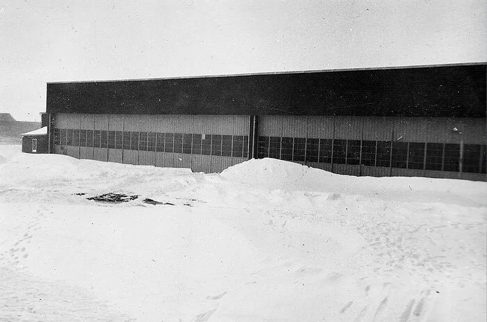
The airport is now the Yorkton Airport (CQV). Of all the former school's buildings, only one of the original seven hangars remain. The abandoned airfield at the former RCAF Detachment Sturdee also remains, but nothing remains at RCAF Detachment Rhein.

A great aerial view of Yorkton's No.11 Service Flying Training School during the Second World War. This view, taken from directly south, shows the endless expanse of Saskatchewan farmland stretching northward. Yorkton sits on the eastern perimeter of the province.

Yorkton's airport today stands on the same spot as No. 11 SFTS during the war, but most of the structures have been razed and runways have been returned to grass lawns.

Another satellite shot shows the relationship of the former BCATP base to the city of Yorkton, Saskatchewan. Image: Google Maps

Many great Commonwealth aviators and airmen graduated from the flying and trade schools of Saskatchewan's contribution to the British Commonwealth Air Training Plan. None were greater nor more loved than Nakomis, Saskatchewan-born Wing Commander Stocky Edwards who, as a Leading Aircraftman, earned his wings at No. 11 SFTS, Yorkton. RAF Photo

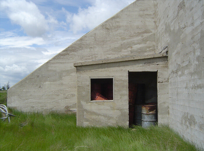
Only one of the original seven massive flight line hangars still exists today.
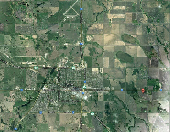
Of No. 11 SFTS, Yorkton's two relief landing fields, the largest was at Sturdee, Saskatchewan. Pulling back from the region, we see the Sturdee triangular field at the lower right corner of this image and Yorkton's airport (CQV) at the top middle. Image: Google Maps

A close-up of the Sturdee relief field shows us that the triangular field still exists, with a road into the field. Image: Google Maps

The last image I leave you with is a shot of the north west corner of the Sturdee airfield. Once a paved triangular field, the runways have now deteriorated and look to be swallowed by the surrounding farmland. This is the fate of all the abandoned airfields of the British Commonwealth Air Training Plan. In a few more decades, only the stories will remain. Image: Google Maps